HuntStand: GPS, Maps & Tools

Advertisement
1M+
Installs
TerraStride Inc.
Developer
-
Sports
Category
-
Rated for 3+
Content Rating
-
http://huntstand.com/privacy
Privacy Policy
Advertisement
Screenshots
editor reviews
🌲📱 HuntStand, developed by TerraStride Inc., is a cutting-edge app that offers a robust suite of GPS, mapping, and hunting tools designed to enhance the experience of outdoor enthusiasts. From detailed weather forecasts and land management features to real-time GPS and a comprehensive library of maps, HuntStand is tailored specifically for hunters and outdoor adventurers. Its intuitive design, combined with a vast array of functionalities, sets it apart in a crowded field of outdoor apps. 🌟🏞️ Choosing HuntStand is a no-brainer for anyone serious about hunting or land management. Its unique blend of social features, such as the ability to share locations and maps with friends, ensures it stands out. Additionally, its commitment to accuracy and detail in mapping technology makes it indispensable for planning and executing outdoor expeditions. 📍🗺️ Whether you're tracking game, plotting land boundaries, or just exploring the wilderness, HuntStand offers an unparalleled user experience. With continuous updates and a keen focus on user feedback, TerraStride Inc. has created an app that not only meets the current needs of the outdoor community but anticipates future demands. 🚀🌳 If you’re looking for an app that bridges the gap between technology and nature, offering rich functionality wrapped in a user-friendly interface, HuntStand is your go-to solution. Download it today and revolutionize the way you explore the great outdoors! 📲💡
features
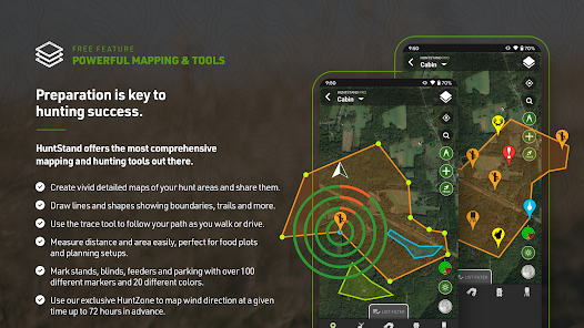
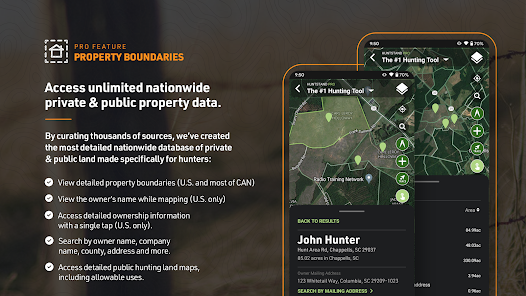
- 🔍 Land Management - Easily mark property lines and manage land details.
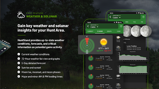
- 🔍 Weather Forecast - Access real-time weather updates and plan your hunts accordingly.
- 🔍 Social Integration - Share maps and locations with your hunting buddies seamlessly.
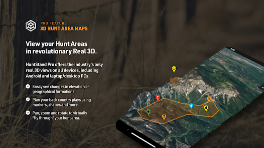
- 🔍 Mapping Precision - Utilize satellite, topographic, and proprietary maps for navigation and exploration.
- 🔍 Real-Time GPS - Track your exact location in the wilderness without fear of getting lost.
pros
- 🌟 User-Friendly Interface - Navigating the app is a breeze, making it accessible for all users.
- 🌟 Comprehensive Toolkit - From land management to weather forecasting, everything you need is in one place.
- 🌟 Regular Updates - The app continually evolves, with new features added regularly based on user feedback.
cons
- 🔻 Data Usage - High-quality map features could lead to significant data consumption.
- 🔻 Learning Curve - First-time users might find the extensive features overwhelming at first glance.
- 🔻 Subscription Cost - Some advanced features require a paid subscription, which might not suit everyone’s budget.
Rating

Recommended Apps
![]()
Logo Maker - Icon Maker, Creat
Z Mobile Apps4.8
![]()
Stocktwits - Stock Market Chat
StockTwits, Inc4.6![]()
WiZ (legacy)
Signify Netherlands B.V.4.6![]()
Cartoon Network App
Cartoon Network3.7![]()
Video Player
Recorder & Music Apps4.5![]()
Lili - Small Business Finances
Lili App Inc.4.3![]()
Chat Translator Keyboard
Ocean Float Mobile4.5![]()
PC Financial Mobile
PC Bank4.4![]()
MirrorPic Mirror Photo Editor
Photo Editor Perfect Corp.4.4![]()
Girly Lock Screen Wallpaper
Prometheus Interactive LLC3.9![]()
Waze Navigation & Live Traffic
Waze3.9![]()
Hair Clipper Prank: Fun Sounds
Braly JSC4![]()
Sleep as Android: Smart alarm
Petr Nálevka (Urbandroid)4.5![]()
iMore Keyboard
iMore Cool Fonts Keyboard Dev.4![]()
NTTA Tollmate®
North Texas Tollway Authority3.1
Hot Apps
-
![]()
Lyft
Lyft, Inc.4 -
![]()
Brigit: Borrow & Build Credit
Brigit4.6 -
![]()
Messenger
Meta Platforms, Inc.4.1 -
![]()
T-Mobile Internet
T-Mobile USA4 -
![]()
PayPal - Send, Shop, Manage
PayPal Mobile4.3 -
![]()
Dave - Banking & Cash Advance
Dave, Inc4.3 -
![]()
Instagram
Instagram4.3 -
![]()
Google Lens
Google LLC4.5 -
![]()
Uber - Request a ride
Uber Technologies, Inc.4.6 -
![]()
United Airlines
United Airlines4.6 -
![]()
Peacock TV: Stream TV & Movies
Peacock TV LLC4.5 -
![]()
Cash App
Block, Inc.4.5 -
![]()
Ticketmaster AU Event Tickets
Ticketmaster L.L.C.2.8 -
![]()
Afterpay - Buy Now Pay Later
Afterpay3.8 -
![]()
WhatsApp Messenger
WhatsApp LLC4.2 -
![]()
GameChanger
GameChanger Media4.6 -
![]()
Google Pay
Google LLC4.4 -
![]()
Planet Fitness Workouts
Planet Fitness3.9 -
![]()
Roku Smart Home
Roku, Inc. & its affiliates4.4 -
![]()
My Spectrum
Charter/Spectrum4.6 -
![]()
eBay: Online Shopping Deals
eBay Mobile4.6 -
![]()
Plant Identifier App Plantiary
Blacke4.1 -
![]()
Direct Express®
i2c Inc.4.3 -
![]()
Green Dot - Mobile Banking
Green Dot4 -
![]()
UnitedHealthcare
UNITED HEALTHCARE SERVICES, INC.4.4 -
![]()
Xfinity
Comcast3.6 -
![]()
Google Meet
Google LLC4.4 -
![]()
Newsmax
Newsmax Media4.7 -
![]()
Fubo: Watch Live TV & Sports
fuboTV1.7
Disclaimer
1.Appinfocenter does not represent any developer, nor is it the developer of any App or game.
2.Appinfocenter provide custom reviews of Apps written by our own reviewers, and detailed information of these Apps, such as developer contacts, ratings and screenshots.
3.All trademarks, registered trademarks, product names and company names or logos appearing on the site are the property of their respective owners.
4. Appinfocenter abides by the federal Digital Millennium Copyright Act (DMCA) by responding to notices of alleged infringement that complies with the DMCA and other applicable laws.
5.If you are the owner or copyright representative and want to delete your information, please contact us [email protected].
6.All the information on this website is strictly observed all the terms and conditions of Google Ads Advertising policies and Google Unwanted Software policy .